Kinnarodden (Cape Nordkinn) in Norway
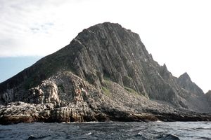
Deep into the Arctic Circle at a latitude of 71°8’2” north, Kinnarodden is the northernmost point of mainland Europe. Unlike the nearby and more celebrated Nordkapp (North Cape) on the island of Magerøya, no car park, famous monument, or expensive café awaits at Kinnarodden. Instead, after a demanding one- to two-day hike across rock fields and scree slopes, you arrive at the northern tip of the European continent, the same latitude as northern Alaska and Siberia, where you are rewarded with a landscape formed by ice and wind.
One of the first records of Kinnarodden comes from the 9th-century Viking chieftain Ohthere (Ottar), who wanted to discover if "any man lived further north than the wilderness" and chronicled that he had sailed as far north as the land had stretched before it then turned southwards to the east into the White Sea and Kola Peninsula in modern-day Russia. Ohthere referred to the route he took as Norðweg, or Northern Way, and this is likely the origin of the name Norway.
At one point, this remote peninsula was inhabited and used as a commercial fishing center. Today it is a conservation area inhabited by grouse, eagles, and domestic reindeer herded north for grazing in the summer months by the Sámi people.
Due to its high latitude, during summer Cape Nordkinn has long cool summers without sunsets or sunrises. If the conditions are right, sun and moon pillars can sometimes be seen—vertical columns of light that appear to extend above and below the sun or moon, caused by light refracting off the surfaces of ice crystals falling from high-level clouds. The orientation of the ice crystals is crucial for the formation of these pillars, as they need to be aligned horizontally to create the effect.