Bruneau Canyon in Bruneau, Idaho
The Bruneau River rises in the Jarbidge Mountains of extreme northern Nevada and flows north into Idaho, meeting the Snake River near the present site of the C. J. Strike Dam. Along the way, it is joined by the Jarbidge River as well as by several smaller tributaries.
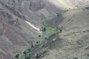
On its way to the Snake, the Bruneau crosses the gently rolling Snake River Plain. However, the Snake River itself has eroded into the plain, such that the river level is now well below the original surface. In response, the Bruneau and its tributaries have carved channels down to the present level of the Snake. This has resulted in spectacular canyons, nearly 1,000 feet deep in places and often hardly wider than their depth. The canyon system extends over 50 miles, and much of the canyons, including the tributaries, have been designated as the Bruneau-Jarbidge Wilderness Area. The wilderness area encompasses the confluence with the Jarbidge River and typically encloses the canyons with a buffer zone a half-mile or so wide. Even where such a buffer doesn't exist, the canyon below the rim is usually designated wilderness.
The country is so remote and access is so difficult, that the canyons remain little known outside the area. Even the most accessible canyon overlook, on the east side of the Bruneau River where the canyon is over 800 feet deep, is not reachable by a paved road, and other viewpoints require high clearance at a minimum and often 4-wheel-drive.
Bruneau Crossing (also called Indian Hot Spring Road) is an example. This is a Jeep road that lies in the middle of the wilderness area, crossing the Bruneau just north of the confluence of the Bruneau and Jarbidge Rivers. Indian Hot Spring, along with some ruins, are in the bottom of the canyon on the west side of the Bruneau. The road is a designated motorized access road through the wilderness (a so-called "cherrystem road"), but within the canyon itself much of it is an extreme shelf road that requires both experienced drivers and adequate vehicles. A new bridge was built across the Bruneau in the last few years, a cooperative project between the Bureau of Land Management and local ranchers, and it makes an incongruous contrast with the extreme Jeep trails it serves. This crossing is also a popular put-in point for river trips down the Bruneau, during the short running season around May at the height of the spring runoff.